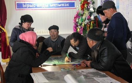
RDF specialists held training sessions to develop community mapping in eight pilot pasture sites in Naryn and Issyk-Kul regions. In addition to members of the Pasture Users Union, specialists from the Community Investment and Development Agency attended the training session, with amost 90 participants.
These seminars were provided as part of the project on “Development of Livestock and Market”, which was funded by the International Fund for Agricultural Development (IFAD) and implemented by the Community Investment and Development Agency.
The aim of these trainings was to help communities develop medium-term and annual plans for pasture management while promoting the development of the community-based pasture mapping tool.
The main advantages of the community pasture mapping tool is that the community can identify its territory, make an analysis of existing and potential pasture resources, and determine their status. The Pasture Users Union can independently, and without spending a lot of money, upgrade maps. In addition to the community-based mapping tool, theoretical and practical training workshops were provided on the use of GPS devices which could be used for the development of community pasture mapping, and GPS navigators were handed to all Pastures Users Union of Naryn and Issyk-Kul regions. Through the training, pasture users also received knowledge and skills in software packages to help with the development and printing of community pasture mapping using GPS devices such as: Google Earth, EarthGPS, and SasPlaneta.
During the training, pasture users made community maps of pastures, checked internal and external boundaries of pastures to determine the existing status, and identified rangeland conditions, potential necessary approaches to pasture control and their conservation efforts.